BonaireTalk Discussion Group
Snorkeling Bonaire: Black Durgon to/from Captain Don's OR Andreas
Bonaire Talk: Snorkeling Bonaire: Archives: Archives 2008: Black Durgon to/from Captain Don's OR Andreas
Top of pagePrevious messageNext messageBottom of page Link to this message  By William Gates (Experienced BonaireTalker - Post #147) on Wednesday, March 19, 2008 - 2:05 pm:     Edit PostPrint Post

From the image on Google-Earth it appears that Halfway between Black Durgon and Capt Dons Habitat is a Filtration Plant [?]
1. Is snorkeling across the facility
A. Restricted? B. Not advised? C. Require Registration, Notification or special permission?

2. Are there any public access points between Black Durgon and Captain Dons other then the easy entry at Cliff?

3. Is there normally any surface current and if so does it run south to north?

4. What about public access and current north of Black Durgon before Andreas I?


Top of pagePrevious messageNext messageBottom of page Link to this message  By David Kaye (Experienced BonaireTalker - Post #207) on Wednesday, March 19, 2008 - 6:26 pm:     Edit PostPrint Post

The plant is the power and water source for Bonaire. To me, it just seems a long way to snorkel to get from Captain Dons to Small Wall. As far as I know, there are no restrictions going by the plant, though. If they have a fuel tanker at the dock, you would have to dodge that.

Current might run either way, but it's probably not going to be strong.

No public access north of the plant until you get to Andrea I. No public access at Black Durgon (only for guests).

David


Top of pagePrevious messageNext messageBottom of page Link to this message  By William Gates (Experienced BonaireTalker - Post #148) on Wednesday, March 19, 2008 - 8:49 pm:     Edit PostPrint Post

David: Thanks for the inputs. A power and water facility makes sense. That wasn't obvious to me from the Google-earth image that I had. As a free member of Google-Earth I don't get their higher resolution images.

Actually, I have no interest in snorkeling past such a facility and especially no interest in having an unplanned encounter with a tanker, so that said, I will plan to enter at Cliff and to turn-around before reaching the power/water station. Then Return to Cliff, Capt Dons or Buddys for a short R&R.

Yes, I am considering staying at the Black Durgon. That will give me easy access to Small Wall and Black Durgons dock and facilities. I'm not sure yet, but I believe it also would provide relatively easy access to Pietre and possibly Andrea 1 and 2 as well. I havent located Pietre yet so I don't know how close it is to Small Wall. Anyone have the Latitude and Longitude of Pietre?

I'm thinking that Andrea to Black Durgon might make an interesting morning snorkel. Its actually less than 1/2 a mile. I prefer to enter at Andrea 1 and snorkel back to Black Durgon. That would not only allow an easy exit [if I'm a guest there] but immediate R&R.


Top of pagePrevious messageNext messageBottom of page Link to this message  By William Gates (Experienced BonaireTalker - Post #149) on Wednesday, March 19, 2008 - 9:35 pm:     Edit PostPrint Post

I went back and checked distances on Google-Earth.

From Andrea I to the pier at Black Durgon is 0.63 miles

From Andrea II to Black Durgon is 0.83 miles.

Both measured via a straight line.


Top of pagePrevious messageNext messageBottom of page Link to this message  By Susan Davis, InfoBonaire, Bon. Insider (Experienced BonaireTalker - Post #184) on Thursday, March 20, 2008 - 8:12 am:     Edit PostPrint Post

I do swim the routes you are proposing. My favorite is from Black Durgon north to the Andreas, but when the wind is stiff, this is going with the surface current, meaning you have to come back against the current, when you might be more tired. I must admit, I don't meander, as on a snorkel, but swim steadily. Of course, I stop to view the occasional passing cloud of blue tangs, or turtle, etc., but the roundtrip--swimming steadily but not at a break-neck speed--takes about 40 minutes.


Top of pagePrevious messageNext messageBottom of page Link to this message  By William Gates (Experienced BonaireTalker - Post #150) on Thursday, March 20, 2008 - 9:57 am:     Edit PostPrint Post

Susan: Great information. Thanks.

I do meander. I take many pictures and each one takes a minute or so; hence, my meandering tends to be quite slow and relaxed [unless, of course, I have to fight a current].

I believe that you are saying that the current is predominantly wind driven? Its my understanding that the winds on Bonaire tend to pick up between 10:00 AM and 4:00 PM. If that is the case, an early morning or late afternoon snorkel might be best if I want to go my preferred direction of Andrea to Black Durgon.

Two more questions:
1. Can you give me any indication of the location of Petries Pillar. Is the site about mid-way? almost to Andrea I? or close by Black Durgon? I can E-mail you a Google-Earth image of the coastline between Andreas and Black Durgon if that would help. I don't believe that Google allows me to post it.

2. Is your 40 minutes round-trip swim using fins?
Bill


Top of pagePrevious messageNext messageBottom of page Link to this message  By David Kaye (Experienced BonaireTalker - Post #208) on Thursday, March 20, 2008 - 9:26 pm:     Edit PostPrint Post

Petries Pillar is quite close to Andrea I.

David


Top of pagePrevious messageNext messageBottom of page Link to this message  By William Gates (Experienced BonaireTalker - Post #151) on Thursday, March 20, 2008 - 11:58 pm:     Edit PostPrint Post

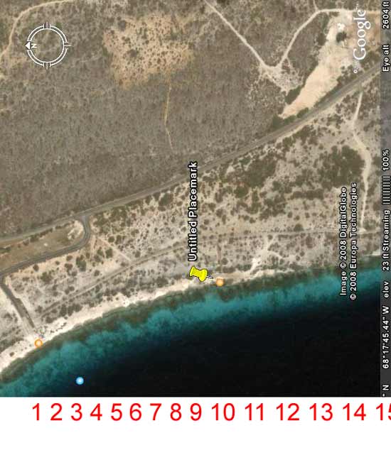
Below is a Google-Earth image showing Andreas sites. I have placed a row of Red Numbers below the Google image.
-- Andreas II is the little orange circle above #1
-- Andreas I is indicated by the point of the yellow pin and is above # 10.

Google Earth Image


Your thoughts as to the location of Petries Pillar would be appreciated. I can extend beyound #15 if necessary.


Top of pagePrevious messageNext messageBottom of page Link to this message  By Susan Davis, InfoBonaire, Bon. Insider (Experienced BonaireTalker - Post #186) on Friday, March 21, 2008 - 8:10 am:     Edit PostPrint Post

Hi William,

Yes, on the surface, the current is generally wind-driven. When it's ripping, I swim south from Black Durgon, so I can ride the current back. However, I don't find this is as satisfying in terms of sightseeing.

When it's more gentle, I go north and don't find it's too much to swim back against it. Of course, the current below the surface does entirely different things.

Yes, winds do pick up during the day, so early morning or late afternoon you'd fight the surface current less..............only detriment is that the sun's not great at those time for images. It also depends on the time of year you're coming.........springtime is noted for winds, while late summer and fall and early December are pretty quiet in terms of wind and are great times to head north from Black Durgon.

Regarding Petrie's Pillar, it's just south of Andrea I. Here's a link to the Marine Park mapping of that area: http://www.bmp.org/divemap/divemap-centre-21-24.html.

And yes, I use fins when I'm swimming. I'm so used to them now, they're just part of me in the water, so I can't imagine swimming without them!

Hope this helps. Susan


Top of pagePrevious messageNext messageBottom of page Link to this message  By Diane Korzeniewski (BonaireTalker - Post #49) on Tuesday, March 25, 2008 - 2:08 pm:     Edit PostPrint Post

Hi,
We have entered the water between Andrea I and Small Wall. We snorkeled S from Andrea, and saw a spot where it was possible to exit, a little break in the coral. Exit, scramble up the embankment, and take stock of where you are on the road. Then come back via car, park on the side of the road, and do the reverse. Have only done it once. Have also snorkeled from Andrea I to Small Wall a number of times. Good luck. Diane


Top of pagePrevious messageNext messageBottom of page Link to this message  By William Gates (Experienced BonaireTalker - Post #153) on Tuesday, March 25, 2008 - 11:05 pm:     Edit PostPrint Post

Susan: Again, Thanks for your inputs. I will probably be coming in the fall -- late September or early October. I was hoping that you would say that you didn't use fins as I would then have had an advantage in that I, of course, would have fins. Worst case wise, if there is a significant current on my return, I can drift/snorkel back to Andres 1 and catch a ride back with a group of divers.

Diane: Thanks for your inputs. As I will be snorkeling alone and not being as young as I once was; I like to plan for possible emergencies [IE alternative exits where I can abort the snorkel if necessary] Do you recall where the entrance/exit you found was [or where you parked your car]?

I have uploaded a Google-Earth view of the shoreline from Andreas 1 to Small Wall [Black Durgon] and thought you might see a familiar point or two. If so I would sure appreciate a number[s] from the ones on the link below.

http://www.falls4sale.com/Google/Andrea-SmallWall.html


You can scroll horizontally to view the entire image.

General: If anyone can locate Petries Pillar on the same image it would be appreciated. The few writeups I've seen on Petrie indicate that it is best done as a "shore dive' so I assume it must have [or had] a shore entry point. Thanks, Bill


Top of pagePrevious messageNext messageBottom of page Link to this message  By Diane Korzeniewski (BonaireTalker - Post #50) on Wednesday, March 26, 2008 - 7:13 am:     Edit PostPrint Post

I can't remember exactly, but the break in coral is somewhere between the narrowing in the road just N of Black Durgeon (2 posts positioned - one on each side of the road) and the turn in the road heading N (where the road block for the back road to Andrea I is). We parked on the R side of the road heading N, as there is lots of room (some house construction there now). I do remember it was easier to pick out a spot from the water. Walking around to access the shore aimlessly is a painful experience due to the sticker bushes. Again, good luck. Let us know how you make out. Diane


Top of pagePrevious messageNext messageBottom of page Link to this message  By William Gates (Experienced BonaireTalker - Post #154) on Wednesday, March 26, 2008 - 7:45 am:     Edit PostPrint Post

Yes, between those sticker things on the shore and the black pin-cushions [urchins] and wave action in the water, I would prefer not to walk around exploring anymore then absolutely necessary.


Top of pagePrevious messageNext messageBottom of page Link to this message  By Jason Prickett (BonaireTalker - Post #11) on Wednesday, March 26, 2008 - 2:15 pm:     Edit PostPrint Post

What are those sticker-bushes called? We were in the park and I had pull these thin acupuncture like needles out of my leg...like pulling out a fish hook it dug in pretty good!


Top of pagePrevious messageNext messageBottom of page Link to this message  By Vann Evans (BonaireTalker - Post #60) on Wednesday, March 26, 2008 - 3:50 pm:     Edit PostPrint Post

We have frequently snorkeled between Andrea 1 and 2 as a drift snorkel depending on which way the wind or current is moving. We have even gone back and forth between the two. It is about 45 minutes either way depending on your speed. We go slow to observe. both andrea 1 and 2 are easily visible from the water as to where to exit. It is about a 15 minute walk back to the vehicle.


Visit: The Bonaire WebCams - Current Bonaire images and weather!
The Bonaire Insider - the latest tourism news about Bonaire
The Bonaire Information Site, InfoBonaire
Search Bonaire - Search top Bonaire Web sites


Topics Last Day Last Week Tree View    Getting Started Formatting Troubleshooting    New Messages Keyword Search Contact Moderators Edit Profile Administration