BonaireTalk Discussion Group
Trip Reports: Spelonk Lighthouse Addendum
Bonaire Talk: Trip Reports: Archives: Archives 2000 to 2005: Archives - 2002-09-26 to 2003-03-31: Spelonk Lighthouse Addendum
Top of pagePrevious messageNext messageBottom of page Link to this message  By Karl H on Saturday, December 7, 2002 - 4:26 am:     Edit PostPrint Post

Boy, once you mess up, there is no way of fixing it. Sorry, webmaster, am still learning the fine art of skanning and posting pictures.

Anyhow, here is what's left of my Spelonk pictures at the moment. My reason for posting? See previous pictureless post.

spelonk1
2,spelonk2


Top of pagePrevious messageNext messageBottom of page Link to this message  By Snorkelguy {Scott} on Saturday, December 7, 2002 - 11:01 am:     Edit PostPrint Post

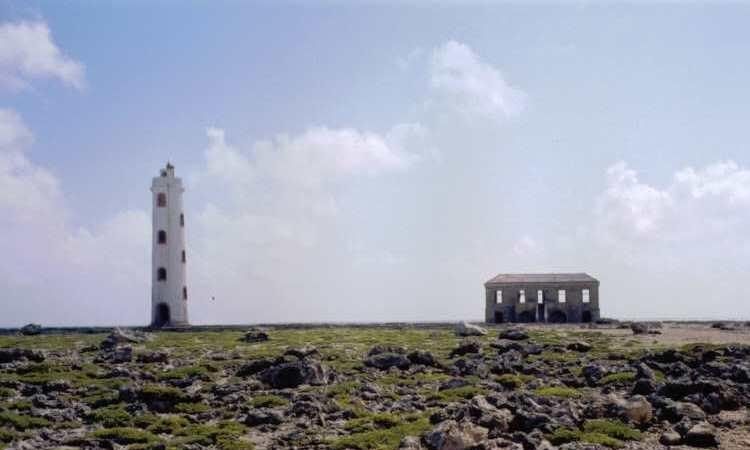
Nice shot Karl. Where is this located on the island?


Top of pagePrevious messageNext messageBottom of page Link to this message  By Glen Reem on Saturday, December 7, 2002 - 12:07 pm:     Edit PostPrint Post

That looks a lot like Willemstoren.


Top of pagePrevious messageNext messageBottom of page Link to this message  By Igor van Riel on Saturday, December 7, 2002 - 12:20 pm:     Edit PostPrint Post

Sorry Glen, it's not Willemstoren.
The lighttower on the picture is the Spelonk Lighttower at the far East corner of Bonaire, Scott.
If u want 2 feel alone on the island, that's were u would want 2 go. I love the place! Be careful though there's no road, only a (long) trail leading 2wards it. U'll need a good map 2, 'cause there are no signs (I would even recommend a compass). Don't drive there with a normal car: u need at least a pickup!


Top of pagePrevious messageNext messageBottom of page Link to this message  By Snorkelguy {Scott} on Saturday, December 7, 2002 - 12:42 pm:     Edit PostPrint Post

You mean there is a “good” map of Bonaire? Where did you ever find it? The map the car rental agencies pass out pretty much only addresses the paved roads and a couple of the major unpaved roads. There were a couple places I couldn’t find or figure out how to get to because the map was so vague.


Top of pagePrevious messageNext messageBottom of page Link to this message  By Anthony Cooper on Saturday, December 7, 2002 - 2:57 pm:     Edit PostPrint Post

Scott - I'm looking at a Bonaire (Dutch Caribbean) "Official Roadmap with dive sites" Identified as 3rd Revised Edition. It was published by the Gerharts Group (a familiar name if ever there was one) and this particular one is identified as being "...compliments of Budget rent a car". It's as good as I've ever seen for the island. Probably printed around '93 - '94. Never had a chance to challenege its accuracy completely, but you might want to try to find one. It is copyrighted by Mapminded, The Netherlands. Worst comes to worst (and if they're still in business} they may have it in their archives. Have fun searching. It does, by the way, show an unpaved road to Spelonk Lighthouse. The fact that Igor says there's no road there may speak to the age of the map!!

DSAO
Tony


Top of pagePrevious messageNext messageBottom of page Link to this message  By Snorkelguy {Scott} on Saturday, December 7, 2002 - 3:16 pm:     Edit PostPrint Post

Sounds like a treasure, hope I can find it!

I might still have the old dive and drive map, perhaps that one was better. I'll have to dig for that one.


Top of pagePrevious messageNext messageBottom of page Link to this message  By Igor van Riel on Saturday, December 7, 2002 - 3:18 pm:     Edit PostPrint Post

Tony,
there is a road 2 Spelonk... well something u might call a road. I prefer 2 call it a trail because u cannot drive it with a normal car and it's on most maps.
Scott,
the map we had with us wasn't that good either. There are more trails than there are on the map and they all look the same. So it's hard 2 find the right way, but we did find it handy 4 orientation and 2 check if u find orientation points u expect (a few old plantation-houses, a gate, etc). The map we had was a laminated one (ideal 4 wet conditions):
B&B Map Bonaire
Berndtson & Berndtson
www.mapmyway.com


Top of pagePrevious messageNext messageBottom of page Link to this message  By Snorkelguy {Scott} on Saturday, December 7, 2002 - 3:23 pm:     Edit PostPrint Post

Thanks Igor, I admit the road was on my map too, really the problem is figuring which road (or trail) is the one that’s on the map since only select roads are on the map and there aren’t any signs. I’m just going to have to try some of them next time and find my way. I couldn’t figure out which road went to the blow-hole just south of Lagoen either. Oh well, all the more reasons to come back another time.


Top of pagePrevious messageNext messageBottom of page Link to this message  By Meryl Virga on Saturday, December 7, 2002 - 6:26 pm:     Edit PostPrint Post

Why bother with a map when ya got a treasure like Bas.....He knows his way around the island like he discovered it!


Top of pagePrevious messageNext messageBottom of page Link to this message  By Karl H on Saturday, December 7, 2002 - 7:46 pm:     Edit PostPrint Post

Hi everyone. I was away from the computer all day... and didn't realize that my picture of the Spelonk Lighthouse caused so much debate...

I found that the "official roadmap" that Anthony referred to was not much help. The one that I used actually was that little one that you get free at the carrental or at any tourist spot.

The road is, as Igor says, not a road but a serious of confusing trails. You need a little courage or daring and a good sense of direction.

I started out at the end of the paved road to Lagoen. Just before the only building at the end of the road -- a restaurant? -- on the left there is a rocky trail without a sign or any other indication that it might go anwhere which leads up a hillside. Once you reach the top, there is a fallen down stone entrance or gate to the right. Enter it and follow the trail to somebody's failed dream, a large stone house in ruins. Stop there and get your bearings. You will see the lighthouse in the distance and part of the road that leads there.

Once you have come down from the ridge, you have to trust your instinct and sense of direction. There are many trails crossing or branching off. Stay close to the coast line when you can see it and you will get there. Once you are in the flats, the road is actually not bad: wide and sandy. However, I probably would not want to tackle it after a rain storm.

I will try again to post my other picture in which you can see the road and the lighthouse from the first ridge at the old stone mansion.

Karl


Top of pagePrevious messageNext messageBottom of page Link to this message  By Leif S on Tuesday, December 10, 2002 - 12:28 pm:     Edit PostPrint Post

Karl:

Your description of how to find the lighthouse is right on target. I only knew that it was on the coast (duh) and North of Lagoen. Once we first spotted it in the distance from the top of a hill near Loagoen, however, it was a fun puzzle to navigate the maze of trails. Going back is just a matter of remembering the various clearings and catcus patches you drove by on the way, but in reverse order.

Next time, I plan on hiking out in the pre-dawn hours and catching a Bonairean sunrise from the top of the lone turret standing against the oncoming sea. Of course, this will only be possible on the last day before flying home, as early morning dives are some of the best.

-LS


Visit: The Bonaire WebCams - Current Bonaire images and weather!
The Bonaire Insider - the latest tourism news about Bonaire
The Bonaire Information Site, InfoBonaire
Search Bonaire - Search top Bonaire Web sites


Topics Last Day Last Week Tree View    Getting Started Formatting Troubleshooting    New Messages Keyword Search Contact Moderators Edit Profile Administration